


Announcements
Meet the 2026 – 2028
GISMO Board of Directors

Dear GISMO Members and Friends,
We are pleased to introduce you to our 2026-2028 GISMO Board of Directors! I, Dara N. Mendeloff, am leading the team as GISMO President, alongside returning Secretary and Board Member Danielle Hartman, Treasurer and Board Member Alan Leidner, as well as Board Members Wendy Dorf and Noreen Whysel, with the addition of new Board Members Himanshu Mistry, Jose Pillich, Chris Rado and Student Board Member Shourya Dokania. Thank you for your service to the NYC geospatial community!
Watch out folks! This is a strong team of GIS professionals, who are representative of GISMO’s legendary membership. Our combined experience spread across generations throughout the expanse of GIS itself. We are local government pioneers, educators spearheading the next generation, entrepreneurs, corporate leaders, and top-notch analysts. Our skills are diverse, from tech to policy, management to design, together we have an extensive understanding of the geospatial world. I am more than excited to work with this team to support our community.
Our GISMO Committees and Member Monthly Meetings are off to a great start and we are excited to share with you reports from the events that our leadership has been involved with! GISMO has long standing relationships with all sectors in the NYC GIS Community, this newsletter hopes to capture a snapshot of all the activity.

Get Involved for 2026!
• Partnerships Committee
• Open Tech Committee
• GeoAI Committee
• Student Committee
• Academic Committee
• Policy Committee
Spatial news
Activities with the GIS Communities Beyond NYC
Written by Alan Leidner
Reports on my activities as I engage with the GIS communities beyond the NYC region. These include memberships in the American Geographic Society (AGS), the National Geospatial Advisory Committee (NGAC), the Open Geospatial Consortium, and the NYS GIS Association. I also maintain ties with Geospatial World, the Geospatial Professional Network (GPN), the National States Geospatial Information Council (NSGIC), and the National League of Cities.
The Open Geospatial Consortium (OGC), of which GISMO is among the few members representing a City, will be holding the 134th Member Meeting in Philadelphia on March 2nd – 5th, which I will be attending. I will be on a panel, speaking about the work of the MUDDI Standards Working group which has developed a data model for underground infrastructure. MUDDI stands for Model for Underground Data Definitions and Integration (more details here: MUDDI – Open Geospatial Consortium). OGC is the international organization that develops geospatial standards. Over the past eight years, OGC has provided funding and support to GISMO to conduct research into underground infrastructure mapping, pandemics/epidemiology, extreme heat, and to develop a pilot for an emergency location and language application (ELLA). In future articles for this newsletter, I will provide more details about these efforts.
In December, 2024 I was appointed as a member of the National Geospatial Advisory Committee (NGAC) which provides guidance to the Federal Geographic Data Committee (FGDC). A major mission of NGAC is to provide feedback from all sectors (states, local and tribal governments, the private sector, academia, and non-profits) on the implementation of the 2025 – 2035 National Spatial Data Infrastructure (NSDI) Strategic Plan. I serve on the NGAC NSDI Committee and have made proposals for using the Census Department’s borders and boundaries layer as a “wireframe” to hold spatial data from all jurisdictions so they can be connected across borders and aggregated into larger areas (including nationally) when needed. For example: wouldn’t it be great if NYC data layers could be integrated with the data from NJ, Westchester County, and Nassau County.
I am pleased to report that New York City continues to be regarded as one of the most advanced users of geospatial systems and technology in the world. However, to maintain this position it will be necessary for NYC to finally hire a Chief Geospatial Information Officer (CGIO), establish a geospatial steering committee composed of GIS managers from all agencies, and develop a strategic plan to guide our GIS efforts and take advantage of the amazing advances in digital twins, geospatial artificial intelligence (GeoAI), and sensor technologies.
The Art and Impact of Data Visualization
Written by Him Mistry
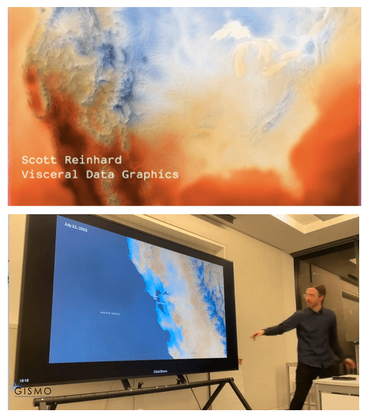
At GISMO’s February 26 in-person meeting, we had the fantastic opportunity to experience a true master class by our guest speaker, Scott Reinhard – cartographer and former New York Times graphics editor – who demonstrated the remarkable power of visual storytelling. He shared a visually striking portfolio that transforms complex, abstract datasets into visceral, intuitive maps.
Highlights included animated tracks of massive wildfires, fluid 3D simulations of San Francisco’s rolling fog, and stunning visual histories of the expanding Starlink satellite array. Scott spoke about his design philosophy of rigorous editing and intuitive clarity – striving to create maps so universally understandable that they ideally require no key.
The session was a powerful showcase of how GIS, animation, and graphic design can come together to engage the public and make critical data accessible. An inspiring evening for anyone working at the intersection of data, geography, and art.
The Evolving Role of GIS Professionals in the Age of AI
Written by Jose Pillich
An upcoming article in the newsletter will explore a pivotal shift occurring in the geospatial field. The piece will examine how artificial intelligence is reshaping traditional GIS roles and redefining the value of geospatial expertise across industries.
The article will also analyze the potential changes needed in geospatial education and professional development to prepare professionals for this evolving landscape. In addition, it will investigate organizational structures that could support elevating geospatial leadership to the executive level, including the possibility of a dedicated C-suite role focused on spatial intelligence.
gismo committee news
Fall 2025 GeoAI Conference Report
Written by Chris Rado
Greetings GISMO NYC-ers from your GeoAI Committee Chair! Fall 2025 was a good one for GeoAI related conferences that presented great opportunities to learn generally about AI and, more specifically, how Geo is being integrated into the rolling snow boulder that is AI. To that end, here is a brief summary of the conferences I attended and the things I found most interesting.
NYS GeoCon, October 8-10, Lake Placid, NY
While AI was not a major theme of this conference, keynote speaker Andrew Turner’s presentation Making GIS Available to Everyone – The Future with AI was a great introduction to what AI is and some ideas about how it could transform the geospatial industry. He introduced the basics of how AI works and ways that ESRI is integrating it into their product and processes. This includes generative coding of Arcade and Python geoprocessing and use of natural language requests to produce answers to geospatial questions, leading to the shocking claim that, maybe, Maps Are Dead. If an AI process can provide a direct answer to a geospatial analysis question, then maybe the maps we would traditionally need to make to show that answer is no longer necessary. All the OG GIS people said yeah, right. But as someone who has made maps for people who can’t understand maps and really just wanted answers, I could kind of see it…
Most significantly, for someone who knew nothing about AI (me), he provided a great resource for learning how all the parts of AI (neural networks, machine learning, and large language models) work. Check out the Neural Networks YouTube video series by 3Blue1Brown. If you want to learn the basics of how AI works, start here! Spoiler- it’s all linear algebra magic math! If you are rusty on your linear algebra, 3Blue1Brown has you covered there too with The Essence of Linear Algebra. Is it all witchcraft? Watch and decide for yourself!
Spatial Data Science Conference, October 15, Columbia University, New York, NY
I wish I took better notes at this one- especially because they gave me a notebook and pen in the goody bag. But really, the most significant thing here was Javier de la Torre’s keynote demo where he showed one way that maps could be dead, per Andrew Turner’s claim. He engaged a Carto-powered agentic AI in a running dialogue to obtain a response to a geospatial analysis task.
He started out with the basic question- how has congestion pricing affected traffic in midtown NYC from 2024-2025? The agent responded with clarifying questions of its own to identify the specific area for analysis and some other parameters needed to answer his question. Ultimately it produced a tabular report showing quantitatively how congestion pricing had reduced traffic in the specified midtown zone from 2024 to 2025. We never saw a map in any of it.
You can check out the conference videos, including Javier de la Torre’s demo, here.
AGS Geography 2025 – GeoAI November 20-21, Columbia University, New York, NY
I took really good notes at this one- yes, I used the notebook and pen I got at the Spatial Data Science conference. Notes were so good that Alan Leidner and I were able to collaborate to produce an actual conference summary document so I won’t go too deep on it here. A summary of the summary for you busy people.
The conference centered on presenting different use cases where GeoAI was being applied, the advantages Geo AI provides, and of more significance to me because these are glossed over or ignored in all the AI hype, the costs, risks, and ethical consideration of AI.
Applications of Geo-enabled AI tools were presented in all of these areas: Finance & Insurance, Climate & Environment, Infrastructure & Mapping, Humanitarian, and Disaster Preparedness and Response. In particular, the Finance & Insurance sectors are really jumping on it due to the potential for identifying new customer opportunities and cost savings. Isn’t that always the case…
The main advantages of AI brings to these application areas were identified as:
superior performance for predictive analyses and simulations; economic impact in risk assessment applications; democratization & education through inclusion of underrepresented populations and teaching opportunities provided by generative AI; and support for large scale, time dependent data operations involving large and frequently updated datasets and continual analytics.
What about risks? Environmental & Resource Strain are significant. AI data centers use lots of water and power, driving up the cost of those resources for consumers and reducing their access to them. Ethical & Societal Concerns- AI amplifies human rights risks when used without transparency, accountability, or consent, due to factors of scale, speed, and autonomy. Further, due to the “black box” nature of how AI works, there are valid concerns with regards to liability, equity, and transparency of AI-based systems.
If I were to provide a single resource to everyone to consult, here is a great one: the Center for AI and Digital Policy. Dig through there a bit and color yourself shocked.
AWS re:Invent Keynote, December 2, Las Vegas, NV
Yeah, I didn’t go to Las Vegas. I watched the keynote online and you can too. My key takeaway from here was that over the course of the 2 hour keynote, one hour and 50 minutes were devoted to everything AI and the remaining ten minutes were for everything else. Stuff to watch out for: AI agents composed of more AI agents; customizable BYOD foundation models; and- you already know this intuitively- the Accenture-estimated cost of technical debt is about 2.4 trillion dollars a year.
If you’re still with me up to here, then you might be a good candidate for GISMO’s GeoAI Committee. We’re meeting monthly via Zoom on the second Monday of each month from 7-8 p.m. If you are interested in this committee, contact me at gismonyc@gmail.com and I’ll invite you to the next meeting.
e: gismonyc@gmail.com w: gismonyc.org LinkedIN: GISMO NYC
Sincerely,
Dara Mendeloff, GISMO President
On behalf of the GISMO Board of Directors: Shourya Dokania, Wendy Dorf, Danielle Hartman, Alan Leidner, Himanshu Mistry, Jose Pillich, Chris Rado, Noreen Whysel